Ancient Lake Bonneville
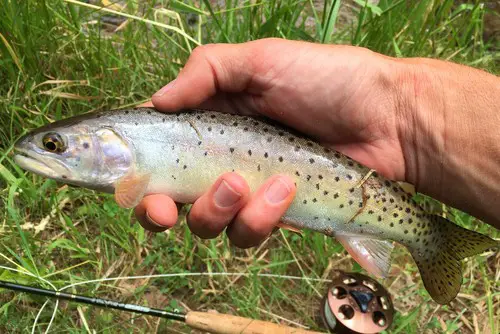
Bonneville Cutthroat Trout are what remains of the apex predator species that once swam in the waters of Lake Bonneville. Lake Bonneville has receded into nonexistence, but Bonneville Cutthroat trout remains in isolated populations in Utah, Nevada, Idaho, and Wyoming, mostly in what were headwater areas of an ancient lake.
Once thought to be extinct
Like all native trout species in the western United States, Bonneville Cutthroat trout did not fare well with civilization. When European American settlers tamed the American West, the resulting habitat changes all but wiped these fish out.
For a period of about thirty years, they were thought to be extinct until an isolated population of them was discovered in Western Utah in the 1970s. Subsequent populations were located in Utah, Nevada, Idaho, and Wyoming. The following is a quote from the Western Native Trout Initiative. “Today, after an aggressive, coordinated recovery effort by a multi-agency conservation team, there are now at least 202 Bonneville cutthroat trout populations that occupy about 2,728 miles of stream in habitat in 21 watersheds in Utah, Idaho, Nevada, and Wyoming.” This article goes over where you can find Bonneville Cutthroat trout in the state of Wyoming.
As of late, there is an interest in catching trout that were native to areas before settlement by European Americans. The fourteen subspecies of Cutthroat comprise many trout species that were native to the Western United States. Wyoming has what is called the Wyoming Cutt- Slam. It is a challenge for fishermen to catch and document the four subspecies of cutthroat trout native to Wyoming in their native waters. Bonneville Cutthroat trout is one of the four subspecies you’ll need to catch to complete the slam.
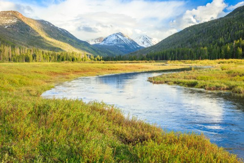
Lake Bonneville was more like a freshwater inland sea than a lake. It once covered an enormous area beneath an equally enormous depth of water. At its peak size, Lake Bonneville covered roughly 20,000 square miles and had a maximum depth of over 1000 feet. Lake Bonneville covered a large portion of Utah’s state, but it also stretched into present-day Nevada, Idaho, and Wyoming.
Catastrophic Geological events coupled with a change in the climate has all but completely drained ancient Lake Bonneville. The Great Salt Lake and Utah Lake are two of its remnant waters. The draining of Lake Bonneville left remnant populations of Bonneville Cutthroat Trout stranded in its headwater streams.
The Bear River and its headwaters are the only places in Wyoming where you can find Bonneville Cutthroat Trout.
According to the book “Trout and Salmon of North America,” By Robert J Behnke, the Bear River strain of Bonneville Cutthroat Trout is adapted to survival in harsh semi-arid ever-fluctuating conditions. They can exist in turbid, silty water during springtime runoff that devolves into warmer, almost nonexistent flows in late summer. Larger Bonneville Cutthroat Trout are also found in the main channel of the Bear River. The warmer, siltier conditions are otherwise unconducive to other trout species. Because of this evolved resilience, the Bear River strain of Bonneville Cutthroat Trout has not been pushed out of their native habitat by introduced trout species. In fact, nonnative trout are rare in all but the very best trout habitat in the Bear River drainages.
In the Wyoming Range
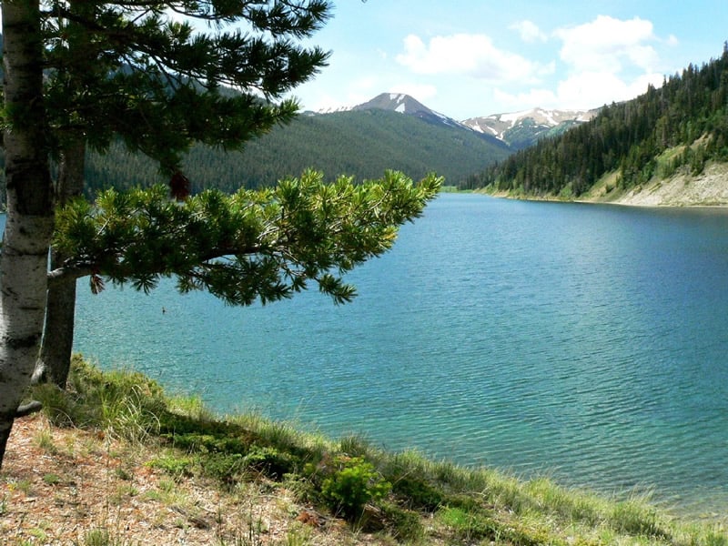
Lake Alice
Lake Alice holds the world’s only known lake dwelling population of naturally reproducing genetically pure Bonneville Cutthroat Trout. It lies behind a natural barrier that keeps things that way. Because Lake Alice’s outlet percolates through the landslide materials that comprise its natural dam, its population of Bonneville Cutthroat trout has been isolated for thousands of years.
Lake Alice had formed thousands of years ago when a huge landslide came down off of what is now known as Lake Mountain, damming off what we now know as Poker creek. The resulting scar on Lake Mountain is still visible today.
The natural reservoir created by the landslide that we call Lake Alice is 3 miles long and has a maximum depth of 200 feet. Lake Alice’s outlet flows for over a mile underground before coming to the surface as Spring Lake Creek. Spring Lake Creek flows for about a half mile before flowing into Hobble Creek. In turn, Hobble Creek flows into the Smith’s Fork of the Bear River.
Lake Alice is 36.1 miles Out of Cokeville, Wyoming. Take WY-232 E for 12.7 miles, then turn right on forest service road 10062. Follow this road for .8 of a mile, then turn left on Forest service road 10193. Forest Service road 10193 for 14.8 miles. You’ll have to ford Hobble Creek to the Hobble Creek campground. Lake Alice is approximately a 1.5-mile hike east of the Hobble Creek Campground. Continue driving past the campground and take another right at the second fork towards Lake Alice Trailhead at the end of the road.
Begin hiking on Lake Alice Trail/National Forest System Trail 1025, crossing the bridge, and staying left at the trail junction beyond the bridge and approximately 1.6 miles to Lake Alice. Once at Lake Alice, stay right and follow the trail along the lake’s southern shore, and Lake Alice Campground is an additional 0.6 miles down this trail.
It’s my understanding that the forest service provides canoes on Lake Alice on a first-come, first-served basis, but some caution should be advised. This is a deep cold Mountain Lake, and there is a history of Lake Alice drowning victims. It’s a relatively short hike or horseback ride from the trailhead to the lake, and if you are planning on doing any floating on the lake, making room in your pack for a life vest makes good sense.
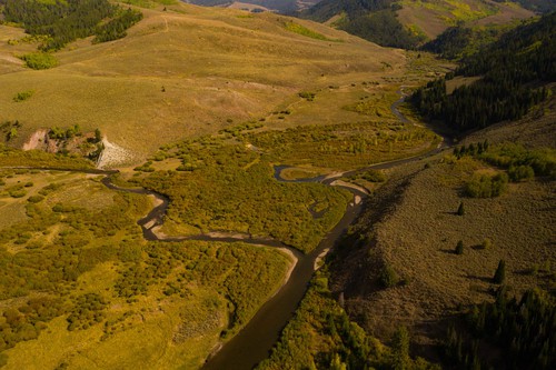
Smiths Fork
Smiths Fork is a tributary of the Bear River. It drains the west slope of the Wyoming Range. The lower section of this river has a mixed population of native Bonneville cutthroat trout, mountain whitefish, and brown trout. The percentage of Bonneville Cutthroat Trout goes up as you travel upriver. The majority of the fish you’ll run onto here will be sub 16 inches.
You have the opportunity, though, to catch larger Bonneville Cutthroat Trout in the Smiths Fork. According to studies conducted by Trout Unlimited’s Ryan Coyler, there are larger Bonneville Cutthroat Trout that spend the winter in the lower main stem of the Bear River feeding on baitfish. These fish will travel up to 95 miles into the headwaters of the Bear River to spawn, then back again. He proved this by surgically implanting radio transmitters into Bonneville Cutthroats from the Thomas Fork and tracking their movements.
Directions to the Smiths Fork River
The following driving directions to the Smiths Fork River are taken from the Wyoming Game and Fish Department’s website. “Take state highway 232 east from Cokeville and continue about 12 miles to where the pavement ends. At this point, the road forks but stay to the left (go straight ahead). Continue another 10 miles on this gradually deteriorating gravel road that’s usually passable by most vehicles when it’s dry but not a good place to drive a car during or after a rainstorm.
You’ll see Hobble Creek canyon coming in on the right (east), at which point you’ll shortly find a two-track, 4-wheel drive road that forks off from the main gravel road and dead-ends at the bottom of the instream flow segment after a half-mile. The main gravel road continues parallel to the Smiths Fork, but you may need an off-road vehicle to get to the stream. You won’t find any developed camping or picnic areas near the segment, but you will find some great fishing for one of Wyoming’s often-overlooked native species.”
Tributaries of the Smith’s Fork
These tributary creeks to the Smith’s Fork River are places to fish for Bonneville Cutthroat Trout. Poker Hollow Creek, Lander Creek, North Fork of the Smith’s Fork, Trespass Creek, Porcupine Creek, Dry Fork of the Smith’s Fork, Hobble Creek, Claudia Creek, Bourne Creek, Sawmill Creek Coal Creek Muddy Creek, Grade Canyon Creek, Bruner Creek, Spring Creek, and Ryan Creek.
Thomas Fork/Salt Creek
This is another tributary of the Bear River that supports native Bonneville Cutthroat Trout. For the majority of its length in Wyoming, it’s known as Salt Creek. Below its confluence with Coal Creek and on down its course through Wyoming and Idaho, it’s considered the Thomas Fork of the Bear River.
Just like with the Smiths Fork, you’ll get the occasional opportunity to fish for larger Bonneville Cutthroat Trout in the Thomas fork. These fish are making a spawning run from or returning to the main stem of the Bear River.
For the majority of its time in the state of Wyoming, Salt Creek Parallels Wy-89. From Smoot Wyoming to Salt Creek and Packstring Creek’s confluence is approximately 14 miles, traveling on 89 south. From Cokeville, Wyoming to the same point on the map is 31.7 miles. Take US-30 West for 10.3 miles to the junction with Wy-89 North. This road meanders across the border into Idaho for a brief stretch becoming Id-61 North. Keep on the same road, and it will junction with route 89 again, coming from the west. By this time, Thomas Fork will be paralleling the road you’re on. Keep to route 89, and it will cross back into Wyoming. From where the road crosses the border, it’s 10.4 miles to Salt Creek and Packstring Creek’s confluence.
Thomas Fork tributaries
- Coal Creek
- Dipper Creek
- Giraffe Creek,
Raymond Creek
Raymond Creek is a Bear River tributary that holds Bonneville Cutthroat Trout. Fishing access is approximately fifteen miles out of Cokeville, Wyoming. To get there from Cokeville, take US 30 north to Border Junction. Take WY 89 north 4 miles, then a gravel road east for 1.5 miles.
Twin Creek
Twin Creek comes down off the Wyoming Range, crosses the border into Utah, and then joins the Bear River approximately 18 miles to the east of Laketown, Utah.
Uinta Mountains
Mill Creek
Mill Creek is a Bear River tributary that rises up on the south slope of the Uinta Mountains in Utah. It crosses the border into Wyoming approximately three miles to the east, where the Bear River makes its crossing.
The Bear River
The Bear River begins in Utah on the South slope of the Uinta Mountains with the Hayden and Stillwater Forks joining. It then flows into Wyoming. Near the town of Evanston, Wyoming, it holds Rainbow Trout, Brown Trout, and native Bonneville Cutthroat Trout. A twenty-inch Bonneville Cutthroat Trout here is not out of the question. The further you follow the Bear River into the backcountry, the lower the percentage of nonnative trout you will find.
Here’s a YouTube video I found on the subject. www.youtube.com/watch?v=YjYR8GEwQrc&t=17s
Fishing Regulations
Lake Alice in Lincoln County. • The creel limit on trout shall be six (6) per day or in possession. No more than two (2) cutthroat trout shall exceed twelve (12) inches. • Fishing is permitted by the use of artificial flies and lures only. • Use of internal combustion engines is prohibited.
Bear River drainage streams, including Smiths Fork and Salt Creek (also called Thomas Fork), drainages, unless indicated otherwise, in Lincoln and Uinta counties. • The creel limit on trout shall be six (6) per day or in possession. No more than three (3) shall be cutthroat trout; and, no more than one (1) cutthroat trout shall exceed sixteen (16) inches.
Recent Articles
The least weasel is the world's smallest carnivore. This little predator is also the smallest member of the Mustelidae or weasel family. They are around 320 times smaller than wolverines,...
The only venomous snakes in Washington State are Northern Pacific Rattlesnakes. The Northern Pacific Rattlesnake (Crotalus oreganus oreganus) is a sub-species of the Western Rattlesnake. Anyone...