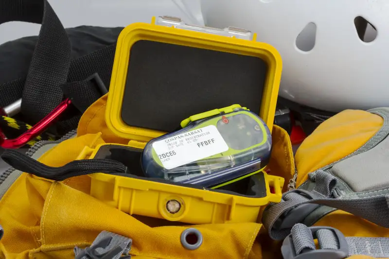
EPIRBs, PLBs, and Satellite GPS messengers provide a lifeline between individuals who are otherwise off the grid and rescue personnel in the event of an emergency.
People who spend time far from the reach of civilization get used to being responsible for their own safety and well-being.
In town, there’s a network of rescue personnel that comes to your aid in the event of an emergency. All you have to do is dial 911, and the appropriate emergency responders will come right to your door, sometimes in a matter of minutes.
Those that are far from any cell signal don’t have that luxury. On the high seas or in the wilderness, you have developed a bit more self-sufficiency. If there’s something out there that you cant handle on your own, though, there are emergency beacons that employ satellite GPS technology to send rescuers your way and help them find you in areas where it would otherwise be impossible.
EPIRB, PLB, and Satellite GPS Messenger are devices you need to signal for help in an emergency. People sailing can face danger if their vessel is damaged when at sea. They can utilize GPS technology to send signals using the devices. The devices are designed in such a way they are easy to operate. People looking for ways they can signal for help fast can utilize them to get the necessary help. They work in any given location on earth through the help of satellites. The different devices apply satellite technology, but their mode of operation varies from one device to another. Below are some of the things you need to know about the different devices:
What is an EPIRB, and how does it work?
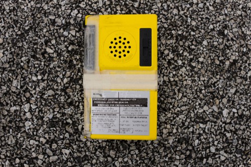
EPIRB stands for Emergency Position Indicating Radio Beacon. By law, the following are required to carry an EPIRB with them at all times.
“all vessels over 300 gross tons, all commercial
fishing vessels regardless of tonnage operating
in waters greater than 3 nmi offshore, and all
inspected vessels engaged in transporting 6 or
more persons for hire regardless of tonnage)” Source
Currently, the recreational craft is not required to carry EPIRBs. It’s common sense for those who venture very far offshore to carry an EPIRB on board.

How many types of EPIRB are there?
There are two. A category 1 EPIRB is designed to hydrostatically release and activate if your vessel sinks. HRUs, “Hydrostatic Release Units,” are designed to release at a depth of 2 to 4 meters. A category 1 EPIRB unit must be mounted somewhere on the outside of the vessel to have an unimpeded release. Category 1 EPIRBs can also be manually activated.
Some examples of CAT 1 EPIRBs:
- From Landfall, MCMURDO SMARTFIND G8 EPIRB – CAT 1 @ $799
- From Landfall, ACR 2830 GLOBALFIX V4 GPS EPIRB CATEGORY 1 @ $559.95
Last updated 12/26/2020 Source
Category 2 EPIRBs can only be activated manually.
Some examples of CAT 2 EPIRBs:
- From Landfall, MCMURDO SMARTFIND G8 EPIRB AIS – CAT 2 @ $549.00
- From Landfall, MCMURDO SMARTFIND G8 EPIRB – CAT 2 @ $599.00
- From Landfall, ACR 2831 GLOBALFIX V4 GPS EPIRB CATEGORY 2 @ $454.95
Source Updated 12/26/2020
What happens when an Emergency beacon is activated?
Quote from Nasa.gov “When activated, it transmits a coded message on the 406 MHz distress frequency which is monitored by the COSPAS-SARSAT satellite system*Sarsat is an acronym for Search and Rescue Satellite-Aided Tracking. COSPAS is an acronym for the Russian words “Cosmicheskaya Sistyema Poiska Avariynich Sudov,” which means “Space System for the Search of Vessels in Distress.” The satellite system detects the signal then sends it to the nearest ground station for action to be taken”. Source
An EPIRB transmits signals to the satellite. The signal consists of an encrypted identification number (all in digital code), which holds information such as the ship’s identification, date of the event, the nature of distress, and chiefly, the position.
The quote is taken from Nasa.gov “Cospas-Sarsat,* an international, humanitarian satellite-based search and rescue system, has helped save over 11,300
lives (as of May 2000) worldwide since its inception in 1982.
The system, which operates 24 hours a day, 365 days a year,
detects and locates transmissions from emergency beacons
carried by ships, aircraft, and individuals.
Sponsored by Canada, France, Russia, and the United
States, the system aims to reduce the time required to alert rescue authorities whenever a distress situation occurs” Source
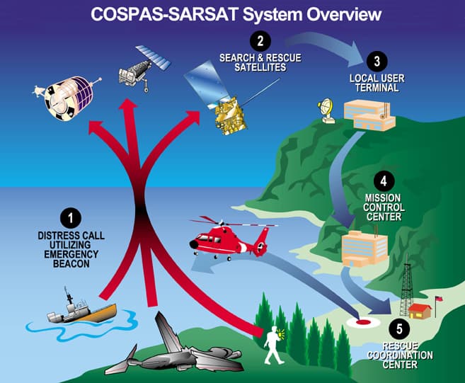
1-In situations of “grave and imminent danger.”
when lives are at risk, emergency beacons are
activated.
2- Satellites relay the emergency alerts they have received
to 38 automatic (unstaffed)
ground stations worldwide. These stations are
called Local User Terminals (LUTs).
3-Alerts are routed to a Mission Control Center
(MCC) in the country that operates the LUT.
Routed messages include the beacon location computed at the LUT if the message is received by
one of the system’s low-Earth-orbiting satellites. Alerts received by system satellites in geosynchronous orbit provide instantaneous alerting and can include location information if the
beacon is a self-locating type.
4-After validation processing, alerts are relayed
depending on beacon location or country of registration (406-MHz beacons only) to either
another MCC or to the appropriate Rescue
Coordination Center
In the United States, Rescue Coordination Centers are operated by the Coast Guard and the Air Force. The Air Force Rescue Coordination Center At Tyndall Airforce Base Florida; coordinates all inland search and rescue operations in the lower 48 states. The actual rescue operations are usually carried out by the Civil Air Patrol, the State Police, or local search and rescue personnel.
In most situations, the U.S Coast Guard conducts maritime search and rescue operations. Coast Guard Rescue Coordination Centers are set up to cover specific geographical areas, and they are as follows:
- District 1- Boston, Maine
- District 5- Portsmouth, Virginia
- District 7- Miami, Florida
- District 8- New Orleans, Lousiana
- District 9- Cleveland, Ohio
- District 11- Alameda, California
- District 13- Seattle, Washington
- District 14- Honolulu, Hawaii
- District 17- Juneau, Alaska
- Puerto Rico RSC- San Juan, Puerto Rico
- Marianas RSC- Gaum Source
When do you need an EPIRB?
All vessels that head into deep waters need this device. If you are going to sail more than two nautical miles from shore, you should ensure you have the device onboard.
GPS Enabled Epirbs Vs. Conventional Epirbs
It takes around five minutes for your location to register with authorities from a GPS-enabled EPIRB. On the other hand, it could take up to 90 minutes using a standard 406 MHz EPIRB for your emergency and your position to be reported.
A non GPS enabled EPIRB unit will pinpoint its location within 2 miles. On the other hand, a GPS-enabled unit is accurate to within a hundred yards.
What is the range of an EPIRB?
There is no specific range for these devices. They utilize a satellite system that can capture signals in any location on earth and then transmit it to the nearest rescue center.
What information does EPIRB transmit?
It transmits coded messages to the satellite that can identify the ship and the date of the event. It can as well let rescuers know about the nature of distress.
What is the difference between a PLB and an EPIRB?
An EPIRB is attached to the ship. PLBs are for the individual crew members. PLB stands for personal locater beacon. They are intended for personal use. Hunters, fishermen, or anyone who spends time outdoors may need a PLB.
How does PLB work?
The land-based system can be activated to transmit the distress signal to the same 406 MHz distress frequency, monitored by the COSPAS-SARSAT satellite system, global systems of satellites used by EPIRB distress calls. The satellites will then relay it to the nearest ground station, where it can be acted upon. ‘‘See the emergency beacon activation section above.”
The 406 MHz satellite signal will get rescuers within two miles of your location. All PLBs have a built-in, low-power homing beacon that transmits on 121.5 MHz. This allows rescuers to home to your location once the 406 MHz satellite system has gotten them in your vicinity. Source
Some newer PLBs also have GPS data integrated into the distress signal. GPS enhanced PLBs will get rescuers to your location even faster.
How much is a PLB?
From ACR Electronics
- The RESCUEME PLB1 sells for $299.95
- The RESQLINK 400 buoyant personal locater beacon sells for $309.95
- The RESQLINK™ VIEW buoyant personal locater beacon with digital readout sells for $359.95
Source There is no monthly subscription to use a PLB.
How do I activate my PLB?
Turn the switch on and leave it there until you receive help or the battery goes dead. Do not attempt to conserve the battery by turning it on and off. When you do this, you interrupt the ability of satellites to acquire and transmit data on your location. Your chance of rescue is much greater if you leave the device turned on for the duration of the life of its battery. If you are in a group and have several devices, then use them one at a time.
When should I activate a PLB?
When you are in a life or death situation that you cant take care of without assistance.
There are instances every year where people call out rescue personnel when they were afraid or insecure. If truth be told, though, they really don’t have an emergency.
When people do this they waste the rescuer’s time and resources that should be devoted to genuine emergencies.
How long does a PLB last?
These devices last an average of five years. It comes in a sealed compartment to make it last longer.
Government regulations require a PLB with a class 2 battery (the type of compact PLBs sold for backcountry use) to transmit at -20°F (-28.9°C) for 24 hours. Source
How much does a PLB rescue cost?
The price tag for some rescue missions runs into the tens of thousands of dollars. Rescue does not cost the person being rescued anything, though.
Make sure you do not activate your PLB erroneously. If you call out rescue personnel because you’re afraid of the dark or some other non-emergency reason, you are diverting money and resources away from people in true emergencies.
Also, when you make a false emergency call, you are needlessly putting rescue personnel in danger. Thirty-two rescuers have died on rescue missions in the National Park Service’s history. Source

What is a satellite GPS messenger?
- Satellite messengers are similar to PLBs in that they enable you to send SOS distress signals from areas where there is no cell phone service.
- They differ from PLBs in that you can send and receive texts.
- Satellite GPS messengers can also be used to do GPS Navigation.
- Satellite GPS Messengers allow people to track you with weigh point updates.
- With the blue tooth feature, you can sync your Satellite GPS Messenger with your smartphone.
- Satellite GPS Messengers use a monthly subscription fee while using EPIRBs and PLBs does not.
How does a satellite GPS messenger work?
Satellite GPS messengers rely on GPS satellites to determine the location and commercial satellite networks to enable communication.
Emergency distress signals are routed to the privately-owned GEOS International Emergency Response Coordination Center, headquartered in Montgomery, Texas. The center will coordinate with local search and rescue agencies and then communicate with you via text as your rescue progresses. Source
How do I choose a satellite GPS messenger?
Your two main considerations should be the features you require and the cost that you are willing or to absorb.
Garmin devices operate on the Iridium satellite network. The following quote is from the Iridium Communications website. “The Iridium network is the largest commercial satellite network in the world and the only network that offers true global communications coverage over 100% of the planet. Uniquely, the Iridium satellite coverage map spans Earth’s polar regions and every inch of land, sea, or sky in between”
Here are some examples of Garmin GPS messengers.
- inReach Explorer @ $449.99
- inReach® Mini @ $349.99
Source Last updated 12/26/2020 Click on the Source tab to locate and research monthly service plans for these devices.
SPOT devices operate on the Globalstar satellite network. Coverage does not completely encompass the globe, as does the Iridium Sat. Network but it may be completely adequate for your needs. Here is a link to coverage maps for Spot devices. Link
Here are a couple of different Spot satellite messaging devices.
- SPOT X2-WAY SATELLITE MESSENGER @ $199.99
- SPOT GEN4SATELLITE GPS MESSENGER @ $99.99
Source Last updated 12/26/2020 Click on the Source link to find each device’s monthly service plan.
Zoleo offers a satellite communication device that works in unison with your smartphone or tablet after downloading their free app. Like Garmin, Zoleo operates from the Iridium satellite network, so their coverage is global. With a Zoleo satellite communication device, you have the following capabilities.
- Message anywhere over satellite, cellular, and Wi-Fi
- SOS alerting with 24/7 monitoring
- Check-in to let others know you’re OK
- Share your GPS location
A Zoleo satellite messenger has an MSRP of $199.00. Source Last updated on 12/26/2020. Click on the Source tab to find and research monthly services plans for this device.
Using the satellite communication devices from any of the three companies I have mentioned requires a monthly subscription fee after you have purchased the device.
Good Luck And Stay Safe As Possible Out There
Nothing worthwhile in life is completely safe. Using the equipment mentioned in this article will put the odds a little bit more in your favor, though.
Recent Posts
The least weasel is the world's smallest carnivore. This little predator is also the smallest member of the Mustelidae or weasel family. They are around 320 times smaller than wolverines,...
The only venomous snakes in Washington State are Northern Pacific Rattlesnakes. The Northern Pacific Rattlesnake (Crotalus oreganus oreganus) is a sub-species of the Western Rattlesnake. Anyone...