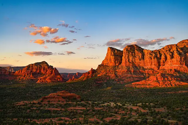
Sedona is a picturesque town that lies within the Coconino National Forest in north central Arizona. The area offers a wealth of breathtaking scenery in the surrounding canyons and red rock plateaus. This is likely the reason that the area has been the setting for the filming of over 60 Hollywood movies through the years.
The area also offers a plethora of hiking trails that showcase the stunning beauty of the red rocks. While Sedona is breathtaking at any time of day, there’s something magical about experiencing a sunset over the red rocks. For those looking to witness this natural wonder, Sedona has several sunset hikes that are worth exploring.
One popular sunset hike in Sedona is the Cathedral Rock Trail. This moderate hike takes about 1.5 hours to complete and offers stunning views of the red rocks and the surrounding landscape. The trail is well-marked and easy to follow, making it a great option for hikers of all skill levels. As the sun begins to set, the red rocks light up in a fiery glow, creating a breathtaking scene that’s sure to leave a lasting impression.
Another great sunset hike in Sedona is the Airport Mesa Loop Trail. This easy 3.5-mile hike takes about 2 hours to complete and offers panoramic views of the surrounding red rocks. The trail is relatively flat and well-maintained, making it a great option for families with children or those looking for a leisurely hike. As the sun sets, the red rocks transform into a kaleidoscope of colors, making this hike a truly unforgettable experience.

Coconino National Forest
Coconino National Forest is a 1.85 million acre National Forest in Northern Arizona that surrounds two cities the first is Flagstaff the second is Sedona. This is a National Forest of contrasts from alpine meadows, ponderosa pine forests, Mogollon rim, and Humphries Peak, which at 12,633 feet is the highest point in Arizona, to the red rock desert and mesas that surround the city of Sedona. The forest is known for its breathtaking views, diverse wildlife, and unique rock formations.
There are several trails in Coconino National Forest that offer stunning sunset views. One of the most popular trails is the West Fork of Oakcreek Trail. This trail is about 8 miles long round trip (4 miles in, 4 miles out) and follows a creek through a narrow canyon. The trail is surrounded by towering cliffs, and the views of the sunset from here are simply stunning.
Another popular trail is the Devil’s Bridge Trail. This trail is about 4.2 miles long and leads to a natural sandstone arch that offers panoramic views of the surrounding area. The sunset views from here are simply breathtaking, and it’s a great spot to take photos.
Coconino National Forest is managed by the U.S. Forest Service, and visitors are encouraged to follow Leave No Trace principles to help preserve the natural beauty of the area. The forest service provides information on the trails, camping, and other activities in the area.
Overall, Coconino National Forest is a must-visit destination for anyone looking for a beautiful sunset hike in Sedona. With its stunning views and diverse wildlife, this forest is sure to leave a lasting impression on visitors.
Best Sunset Hikes in Sedona
Sedona is known to be one of the best places in the world to see stunning red rock formations, and the best way to experience them is by hiking. Hiking during sunset is an even more magical experience, with the sky changing colors and the rocks glowing in the warm light. Here are some of the best sunset hikes in Sedona:

Cathedral Rock Trail
The Cathedral Rock Hike is a moderately challenging but rewarding hike that offers panoramic views of Sedona’s red rocks. The trail is steep and rocky, with an elevation gain of 551 feet, but the vantage point on top of Cathedral Rock is worth the effort. The best time to hike this trail is during sunset when the rocks light up in a beautiful golden hue.
To get there, take Route 179 South, 7.3 miles to Oak Creek Village, then take a left on Back O’ Beyond road and travel west for about a mile. The Cathedral Rock trailhead parking lot will be on your left. Thursday through Sunday, there is no parking allowed in the Back O’ Beyond parking lots. When the parking lots are closed, hikers are asked to park at the park and ride lot located at 1294 SR 179 and use the free shuttle service to get to the trailhead.

Airport Mesa Trail
The Airport Mesa Trail is an easy hike that offers stunning views of Sedona’s red rocks. The trail is only 3.5 miles round trip and has an elevation gain of 314 feet. This trail circles the upper slope of Airport Mesa. To the east of the trail, you’ll see the “Twin Buttes,” while to the North, you’ll see Thunder Mountain, Chimney Rock, and Coffee Pot Rock. You’ll have a view of Cathedral Rock to the south. However, that view improves if you take the Tabletop trail.
The Tabletop Trail
The Tabletop Trail is a half-mile-long out-and-back spur that originates from the airport loop trail. It affords great views of Oak Creek Canyon, Cathedral Rock, and Pyramid Mountain. This is an especially good spot to view Cathedral Rock at sunset.
To get to the airport loop trail, From the junction of Routes 89A and 179, take 89A west 1.0 miles to Airport Road on the left. Go 0.5 miles and park in the turnout on the left.

Devil’s Bridge Trail
Devil’s Bridge is the largest natural sandstone arch in the Sedona area. Devil’s Bridge Trail is a popular hike that offers breathtaking views of Sedona’s red rocks. The trail is 4.2 miles round trip and has an elevation gain of 564 feet. The vantage point at the top offers panoramic views of Sedona and is the perfect place to watch the sunset.
On the west end of Sedona, turn right on Dry Creek Road and drive 2 miles to where FR152 splits; at this point, take the right-hand fork onto a dirt road. This route is for high-clearance vehicles only. ( See the alternate route listed below for low-clearance vehicles.) This route is also questionable during periods of wet weather. About 1.3 miles up this road, the Devils Bridge Trailhead parking lot will be on your right.
Passenger cars and all other low-clearance vehicles can park at the Dry Creek Vista Trailhead at the end of the paved section of Dry Creek Road. Just after the right-hand turn mentioned in the above paragraph. This route adds an additional 2.1 miles one way to your trip.

Bell Rock Trail
Bell Rock Pathway is an easy hike that offers stunning views of Sedona’s red rocks. The trail is only 3.6 miles round trip and has an elevation gain of 500 feet. It offers fantastic views of Bell Rock which is one of Sedona’s most recognizable landmarks, and Courthouse Butte, as well as other landmarks. The vantage point at the top offers panoramic views of Sedona and is the perfect place to watch the sunset.
To get there, take route 179 from the junction of 179 and 89A in Sedona, 3.6 miles to the trailhead parking lot at milepost 309.8.

Boynton Vista Trail
The Boynton Vista Trail is a moderately difficult hike that offers stunning views of Sedona’s red rocks. This is a 1.1 miles round trip hike and has an elevation gain of 147 feet. The trail ends at the base of Boyton Spire. The vantage point at the top offers panoramic views of Sedona and is the perfect place to watch the sunset.
If you are there to watch the sunset, be sure to carry headlamps because the way back down in the dark could be slightly treacherous.
To get there, park at the Boynton County trailhead. Note that parking at the trailhead is limited. Take the canyon trail for approximately .4 miles. A side trail opens to the right, which goes for .2 miles to the Vista.

Doe Mountain
Doe Mountain is a moderate hike that offers stunning views of Sedona’s red rocks. The trail is 1.2 miles round trip and has an elevation gain of 400 feet. From the top of Mesa, you’ll have panoramic views of Bear, Maroon, and Wilson mountains, Loy, Boynton, and Secret Canyons, Chimney Rock, and the Cockscomb, to name a few. Sedona is visible to the east and off to the south, Munds Mountain and Sycamore Pass mark the location of Sycamore Canyon and the Verde Valley.
This is the perfect place to watch a Sedona Sunset.
To get there, take dry creek Road from the west end of Sedona, and turn north for 3 miles to the Boynton Canyon intersection. From the intersection, turn left on FR152C. Take this road for about a mile to the trailhead.

Red Rock Crossing
The Red Rock Crossing trail is located in Red Rock State Park, which is located outside of Sedona.
Red Rock Crossing is one of the most popular hiking trails in Sedona, known for its stunning sunset views. The trail is located in the Coconino National Forest and offers a moderate hike suitable for all skill levels.
To access the trailhead, visitors will need to purchase a Red Rock Pass, which is available at several locations in Sedona. The pass is required for all vehicles parked at the trailhead and helps fund the maintenance of the area.
The trail itself is approximately 1.8 miles round trip and takes hikers through a beautiful landscape of red rocks and lush vegetation. The trail offers stunning views of Cathedral Rock, which is one of Sedona’s most iconic landmarks.
As hikers approach the end of the trail, they will reach Red Rock Crossing, a picturesque area where Oak Creek flows through a series of shallow pools and cascades. This area is a popular spot for picnicking, swimming, and enjoying the sunset views.
Hikers are encouraged to bring a camera to capture the breathtaking views of the sunset on top of Cathedral Rock. The area is also known for its stargazing opportunities, as the lack of light pollution allows for an unobstructed view of the night sky.
Overall, Red Rock Crossing is a must-visit destination for anyone looking to experience the natural beauty of Sedona. Its moderate difficulty level, stunning views, and proximity to the city make it a popular choice for locals and tourists alike.
The Red Rock Crossing trail is located 7 miles southwest of Sedona. To get there from Sedona, take US 89 and then turn south on SR 217 just outside of town. Then drive about 1 1/2 miles and follow the signs to the Red Rock Crossing. Note that you will need a $5 Red Rock pass to park at any of the trailheads within the state park.
Huckaby Trail
The Huckaby Trail, which was constructed in 1998, is a 5.7 mile, out and back route. You can access this trail from either the Schnebly Hill trailhead or the Midgley Bridge. The Huckaby trail offers views of Steamboat Rock, Wilson Mountain, and Midgley Bridge from the top of Mitten Ridge.
To get to the Schnebly Trailhead, head south from Sedona on State Route 89A toward Forest Road at the roundabout, and take the third exit onto AZ-179 S. At the next roundabout, take the second exit on Schnebly Hill Rd to the trailhead.
To get to the Midgley Bridge from Sedona, take Route AZ-89A N for 1.6 miles to the mouth of Oak Creek Canyon and the Midgley Bridge turnout.
Note that you will need a $5 Red Rock pass to park at any of the trailheads within the state park.

Oak Creek Canyon
Oak Creek Canyon is a world-famous picturesque gorge that is carved into the edge of the Mogollon rim. It is world-famous for its spectacular scenery. In fact, some people go so far as to call it the smaller cousin of the Grand Canyon.
West Fork Trail
One of the best hikes in the canyon is the West Fork Trail. This trail follows the course of the West Fork of Oak Creek. for its stunning views of the surrounding mountain range and is a great option for hikers of all skill levels. The trail is relatively easy, with only a few steep sections, and is approximately 6.5 miles round trip.
The end of the maintained trail is marked accordingly with a sign. However, some people opt to continue on through the full course of the canyon, which is 14 miles long from end to end. Past the end of the Forest Service trail, the hike becomes more difficult, with a lot of hiking in the stream bed and some areas of deep water.
North Wilson Trail
The North Wilson Trail begins just north of the Encinoso picnic area, which is three miles up the canyon from Midgley Bridge. The trail joins the Wilson Mountain trail halfway up Wilson Mountain.
The view from the top encompasses territory that stretches out for hundreds of square miles of picturesque red rock country that includes Sedona, Coffee Pot Rock, Oak Creek Canyon, Sterling Canyon, Capitol Butte, and the Verde Valley.
Overall, Oak Creek Canyon is a must-visit destination for anyone looking to catch a beautiful sunset in Sedona. With its stunning pass, surrounding landscape, and mountain range views, it’s no wonder why this destination is so popular among hikers and nature enthusiasts alike.

Munds Wagon Trail
Munds Wagon Trail is a relatively easy hike. The trail roughly parallels Shnebly Hill Road, crossing it occasionally. From here, you will have great views of Sedona and the red rock desert. In wet periods you will come upon small pools of runoff water that mirror the red rocks creating some great photo-taking opportunities.
The Munds Wagon Trail and Shnebly Hill Road eventually lead to the Cow Pies Trailhead. The Cow Pies is a geologic formation that is actually shaped like cow pies. These slick rock mounds are visible in several Western movies filmed from 1930-1968. Including The Last of the Duanes, Leave Her to Heaven, Angel and the Badman, The Strawberry Roan, Broken Arrow, The Last Wagon, and Stay Away, Joe. Beyond the Cow Pies, you will have a great view to the east of the Mogollon Rim and to the west of Mingus Mountain and Jerome. See
To get to the Munds Wagon Trailhead, head south from Sedona on State Route 89A toward Forest Road at the roundabout, and take the third exit onto AZ-179 S. At the next roundabout, take the second exit on Schnebly Hill Rd to the trailhead.
Important Notes
When planning a sunset hike in Sedona, there are a few important notes to keep in mind. First and foremost, it’s crucial to consider the skill level required for the hike. Some trails, such as Cathedral Rock or Devil’s Bridge, are more challenging and require a higher level of fitness and experience. On the other hand, easier hikes like Bell Rock or Airport Mesa are more accessible to beginners.
Another important factor to consider is trailhead parking lots. Some popular trails, such as Cathedral Rock and Devil’s Bridge, have limited parking spots that fill up quickly, especially during peak season. It’s recommended to arrive early to secure a parking spot or consider taking a shuttle service.
It’s also important to note the best time of year to hike in Sedona. While the winter months can be less crowded and cooler, the summer months can be scorching hot and crowded. It’s best to plan accordingly and bring plenty of water and sunscreen.
When planning a sunset hike, it’s important to time it right. The late afternoon is the perfect time to start the hike, as it allows enough time to reach the end of the trail before the sun sets. It’s recommended to check the sunset time beforehand and plan accordingly.
It’s also important to consider that if you are going out on a hike to watch the sunset, you will be hiking back in the dark. Everyone in your group should be equipped with a headlamp and extra batteries to light your way back to your car.
Finally, it’s important to respect the trails and natural surroundings. Stay on designated paths, pack out all trash, and avoid making excessive noise. By following these important notes, hikers can safely and responsibly enjoy the stunning Sedona sunset hikes.

Additional Activities
Jeep Tours
For those who want to explore the surrounding area of Sedona in a different way, jeep tours are a popular option. These tours offer a unique perspective of the red rocks and canyons and are a great way to see the area’s natural beauty up close. Jeep tours can be booked through various companies in Sedona, and they typically last between 2-3 hours. Some tours even offer sunset options, which can be a great way to end a day of hiking. Click here for more information.
Hot Air Balloons
For a truly breathtaking experience, hot air balloon rides are a must-do in Sedona. These rides offer a bird’s eye view of the red rocks and canyons and are a peaceful way to take in the area’s natural beauty. Hot air balloon rides typically last around an hour and are offered at sunrise or sunset. While they do come at an extra cost, they are a once-in-a-lifetime experience that is sure to be unforgettable.
Overall, Sedona offers a variety of different ways to explore the area beyond just hiking. Whether it’s a jeep tour or a hot air balloon ride, there are plenty of activities to choose from that will allow visitors to see the area’s natural beauty in a unique way.
Where to Stay
Arabella Hotel
The Arabella Hotel is a popular choice for visitors to Sedona who want to be close to the hiking trails. This hotel is located in the heart of Sedona and is just a short drive away from some of the best sunset hikes in the area.
One of the main advantages of staying at the Arabella Hotel is its proximity to the hiking trails. The hotel is just a short drive away from some of the most popular sunset hikes, such as Cathedral Rock and Bell Rock.
The Arabella Hotel also has a range of facilities to make your stay more comfortable. There is an outdoor pool and hot tub, as well as a fitness center and a spa. The hotel also has a restaurant and bar, which serves a range of local and international cuisine.
Overall, the Arabella Hotel is a great choice for visitors to Sedona who want to be close to the hiking trails. The hotel is conveniently located and has a range of facilities to make your stay more comfortable.
Conclusion
For those looking to experience the beauty of Sedona’s sunsets, a sunset hike is a great option. With so many trails to choose from, it can be difficult to decide which one to take. However, based on popularity and good reason, a few hikes stand out as the best way to experience a sunset in Sedona.
One of the most popular hikes for sunset viewing is the Cathedral Rock Trail. This trail offers stunning views of the red rock formations and requires a moderate level of fitness. The trail can get crowded, but the views are worth it.
For those looking for a quieter option, the Doe Mountain Trail is a great choice. This hike offers panoramic views of the surrounding landscape and fewer people on the trail. It’s a good idea to bring a flashlight for the hike back down after sunset.
Another great option is the Airport Mesa Trail. This trail is a favorite among locals and offers stunning views of the sunset and the city below. The trail is easy to moderate and is a great option for families with children.
Overall, Sedona offers a variety of sunset hikes to choose from, each with its own unique views and experiences. It’s a great way to end the day and take in the beauty of the area. As always, it’s important to stay safe and bring plenty of water and snacks for the hike.
